


- Emily Grossnickle
- Post-doctoral scientist
- Cognitive and Neural Correlates of School-Based Improvements in Spatial Thinking
- James Madison University, Georgetown University
- Dan Goldman
- Lab Manager
- Cognitive and Neural Correlates of School-Based Improvements in Spatial Thinking
- Georgetown University
- Adam Green
- http://cng.georgetown.edu/
- Assistant Professor
- Cognitive and Neural Correlates of School-Based Improvements in Spatial Thinking
- Georgetown University
- Emily Hollenbeck
- Cognitive and Neural Correlates of School-Based Improvements in Spatial Thinking
- Northwestern University
- Bob Kolvoord
- Dean
- Cognitive and Neural Correlates of School-Based Improvements in Spatial Thinking
- James Madison University
- David Uttal
- http://groups.psych.northwestern.edu/uttal/
- Professor
- Cognitive and Neural Correlates of School-Based Improvements in Spatial Thinking
- Northwestern University


Public Discussion
Continue the discussion of this presentation on the Multiplex. Go to Multiplex
Richard Hudson
Senior Executive Producer
Fascinating research project. Where are you in the timeline at present? Any pilot experiments so far? Please share what you’ve learned so far.
Emily Peterson
Post-Doctoral Scientist
We are just beginning end-of-year data collection for the first cohort of students in the study. Two interesting take-aways from a pilot study and beginning-of-year data collection are (a) spatial thinking is important in high school education, even when students are reasoning about problems that are not explicitly spatial, and (b) the Geospatial semester course can support spatial reasoning for these types of problems.
A pilot study comparing students in the Geospatial Semester course (GSS) to students in other AP science courses suggested that as the year progressed, GSS students used more spatial terminology when describing how to solve problems. This was true even when questions were not explicitly spatial (e.g., “Why do you think gas prices differ from station to station?”).
For students in the first cohort, we have started to examine the relations between some of the different spatial tasks students completed before the GSS course. Preliminary results indicate that performance on spatial tasks such as mental rotation predict logical/syllogistic reasoning (A is taller than B; B is taller than C; Is C taller than A?), for both spatial relations (e.g., right/left, above/below), as well as non-spatial relations (e.g., taller/shorter, better/worse). Preliminary fMRI evidence from these students suggests that they may be recruiting neural resources from areas of the brain important for spatial thinking, even when solving logical reasoning problems.
Kim Kastens
Thanks for the additional detail.
But surely “taller/shorter” is a spatial relation….
Emily Peterson
Post-Doctoral Scientist
Thanks for the comment. I think there’s a difference between whether something is spatial by nature, or whether we “spatial-ize” it by creating a spatial array or mental model to represent the relations between objects. We did follow-up interviews with students, and, consistent with prior studies, they often reported lining up the objects in horizontal or vertical arrays as a way of answering the problem. However, imagining A on the left and B on the right (or A on top and B below) is not an actual depiction of taller/shorter, rather a mental representation that they are using to solve the problem. This is different than a left/right example (e.g., A is left of B), where visualizing A to the left of B directly corresponds to the relative spatial location of the objects.
Emily Peterson
Post-Doctoral Scientist
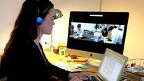
Welcome to the discussion of our project, The Cognitive and Neural Correlates of Spatial Thinking, lead by PIs Bob Kolvoord, Adam Green, & David Uttal. This project brings high school students into the neuroscience lab to understand how classroom-based education (i.e., the Geospatial Semester) impacts students’ spatial problem solving. We look forward to responding to your thoughts and questions.
Kim Kastens
What do the kids think about this project; are they intrigued or freaked out that their brains might be changing?
Emily Peterson
Post-Doctoral Scientist
For the most part, the students have been very enthusiastic about the brain scans and I think they (and especially their parents) are hoping that there are changes. The students I talk to seem to think it is common sense that their brains are not yet fully developed. This might have to do with what they learn about brain development in biology courses or from the media, but part of it might be related to the push in K-12 education in Virginia (and nationally) for developing “growth mindsets” (Dweck), with phrases like “grow your brain” being pretty commonplace for these students.
Robert Tinker
I bet this project is what the NSF might categorize as high-risk, high-gain. Kids’ lives are so complex and development is happening so fast at these grades, I would be surprised to see brain differences that can be separated from the noiss and attributed to a minor intervention over a long time. I would be delighted to be surprised. Is there supporting evidence that makes you think that you can demonstrate a connection between your intervention and the resulting scans?
Emily Peterson
Post-Doctoral Scientist
I can’t argue that there is a lot of complexity going in students’ lives outside of this class. One thing that will help to attribute the results to the intervention is propensity score matching, which we used to match students taking GSS and students taking other sciences (control) on a variety of indicators related to spatial ability and academic performance (GPA, PSAT, number of science classes taken). The GSS course takes place over 1 school year, 90 minutes every other day or 45 minutes every day depending on the school. There is evidence that performance on spatial tasks is malleable even with brief interventions (David Uttal and colleagues have a 2013 meta-analysis on this if you’re interested). Further, training studies have demonstrated functional as well as structural changes (in white and grey matter) over shorter training periods. Studying the neural effects of school-based learning is new territory though, so we are cautiously optimistic.
Jerry Valadez
CEO
Thank you for the work you have undertaken. I hope your results are disseminated with a lot of support to do so. There certainly would be interest and high hopes. What is your plan for disseminating this important work when you have data and impact predictions? Do you think there would be a backlash from the ‘status quo’? Are your student groups diverse enough to look at demographic data across cultures and ethnicities?
Emily Peterson
Post-Doctoral Scientist
We have presented preliminary results at the American Educational Research Association, and will present further analyses this summer at the Spatial Cognition conference, the conference for Mind, Brain, and Education, and ESRI’s GIS user conference. There will be many different audiences for whom these results may be of interest, including psychologists and neuroscientists, as well as classroom teachers, and geoscientists (to name a few). Regarding your question of demographic differences, our sample is about 30% non-white minority students, so we will have the opportunity to take a look at this.
Bernadette Sibuma
Very interesting project! As fMRI scans alone can be quite expensive, I’m curious about your research design and how you collaborate with the schools to obtain student time for the scans. Could you say a bit more about that and your sample size?
Emily Peterson
Post-Doctoral Scientist
Coordination is definitely one of the more challenging aspects of a project like this. We are scanning 80 students over two years. They come in once at the end of their junior year and again at the end of their senior year. We work with schools to get into junior-level classes to recruit students and hand out consent forms for them get signed by parents and return. These forms include contact information for parents so that we can get in touch with them directly. Teachers have been our best allies for getting students to remember to return forms.
Once students return the forms we give a short 20-30 minute packet that includes paper folding and survey items, typically during their study hall. In this packet students also answer questions about whether they are interested in coming in for a scan. From that point on, we work with the parents individually to schedule times for students to come in, either for a scan (N=80) or for other behavioral testing (N=100). A lot of our testing has been over the summer or on weekends so that it doesn’t interfere with the school day.
Alycia Hund
You mention sex differences in your description. Do your preliminary findings offer any concrete details regarding patterns of similarity and difference?
Emily Peterson
Post-Doctoral Scientist
Based on the data we’ve collected so far, we see males outperforming females on mental rotation, but not on some of the other spatial tasks such as embedded figures and paper folding. We also collected a number of predictors, including experience with spatial activities and spatial habits of mind (e.g., when I am thinking about a complex idea, I use diagrams, maps, and/or graphics to help me understand). Interestingly, preliminary analyses indicated that experience with spatial activities in high school, especially playing videogames, is a strong positive predictor of all of these spatial tasks for females, but not for males. Additionally, experience with spatial activities in childhood (e.g., playing with blocks) strongly predicts spatial habits of mind in high school for females, but not for males.
Andrew Izsak
Hi EMily,
Very interesting project. At least in the video, geospatial thinking is presented as a monolithic thing. Is it all about spatial rotations, or are there other important subclasses? If so, will you be looking at differences in scans based on students’ experiences with different subclasses of geospatial thinking?
Andrew
Emily Peterson
Post-Doctoral Scientist
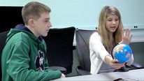
Good point. We are looking at a few different types of spatial thinking. In addition to mental rotation we have students complete an embedded figures task and a syllogistic reasoning task in the scanner. MRT & EFT were selected based on a framework by David Uttal and others that suggests that spatial thinking is not unidimensional. Outside of the scanner we are having students engage in geospatial thinking (e.g. interpreting maps) using a Spatial Thinking Test developed by Lee & Bednarz. Additionally, we videotaped students while they responded to scientific reasoning questions, such as: how would you go about running a campaign to increase recycling by your community?, and if your city needed a new landfill and you were in charge of the process, how would you go about determining where it should be located? These questions can be answered in spatial or non-spatial ways, and we will be examining the degree to which students in the GSS course (relative to the comparison group) discuss these problems using spatial language.
Further posting is closed as the showcase has ended.